Here is a bit more fire info. This google earth fire mapping shot taken July 16th mid morning.
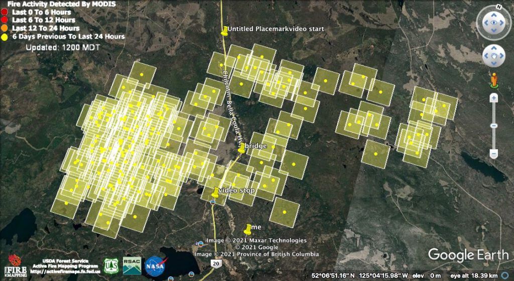
The yellow does not necessarily mean temperature. If you look at the scale in the top left corner, you will see that yellow means activity 6 days previous to the last 24 hours. It will still be burning. But no new hot spots have happened for a while. Winds have lessened, temperatures have cooled, and there have been little bits of rain.
The First Nations chief from Anahim Lake drove through the area on the afternoon of July 14, two days earlier. A video of the drive-through is posted on this link to the 100 Mile Free Press. Scroll down a bit to see the video.
It starts at the mark on the above map just north of the fire area. It is a viewpoint with a steep hill below, about 5 km from the bridge. The bridge comes up about 2/3 of the way through and the video stops at the Bit Stick Lake turnoff.
My turnoff is bypassed, but immediately before the bridge, the camera pans quickly to the left where flames are quite busy. I am pretty sure that is a pocket of spruce right next to the beginning of my driveway.
Checking out the weather and Windfinder, I decided to try and make a quick trip home to pick up more stuff, tomorrow, Sunday 18th. Highway 20 through Kleena Kleene was opened, but the one through the Hotnarko fire in the north at first remained closed, and then was opened at 3.00:AM to 11.00:AM. A pilot car would guide traffic. When the pilot car steered people around the 2010 flood, it went every two hours. If you missed the time you had to wait 2 hours for the next one. I organized myself to leave the Bella Coola Valley at 2.00:AM to be at the western barrier in time, but in fact today they have lifted the time restrictions, with the proviso that the highway can be closed at any time. This means I should be home and back in a day. Winds tomorrow are supposed to flip and be very gentle from the north. Shouldn’t be much fire danger, but its likely to be very smoky.
This morning I received excellent news. Search and Rescue members went in yesterday and wrote:
….there was a cat blocking the road and more cats coming to put a guard in all the ways to the smoky road km 31 and so there should be a good guard by the time you get there. A forestry boss was on road and he assured us that yours and Jades place were wetted down good.
SoI’m expecting everything to look very different!
Hi Chris – glad to hear they are reopening the highway for a spell and that they are building a guard near your place. I’m guessing they pumped water from the creek to water down Jade’s and your place. I only cottoned on to this blog a couple of days ago, so have a lot of “back reading” to do! We had a system come through yesterday, bringing a bit of rain in the morning, then clearing some of the smoke out and later in the evening a couple of thunder clouds and a good downpour. Everything feels so much better now. But the heat is returning and it will be dry very quickly again.
Chris, Anne and John in Chemainus sending you our best thoughts and wishes for a safe journey and that you find your home and out buildings all secure and in good shape. We admire your courage in heading there to check on everything. Be safe and first and foremost be careful. You are in our thoughts and prayers for your safety. Many of your ‘friends’ through your blog and your many books are with you in spirit.